LegendCON - A new world in progress

Discuss your new mods and themes here

Moderator: Defcon moderators

User avatar
Lazureus
level1
level1
Posts: 19
Joined: Fri Oct 06, 2006 3:15 pm
Contact:

LegendCON - A new world in progress

Postby Lazureus » Sat Oct 07, 2006 1:50 am

I've been making a new mod for defcon, combining landmasses from various stories i was writing in the past. It's a new world map!

Image

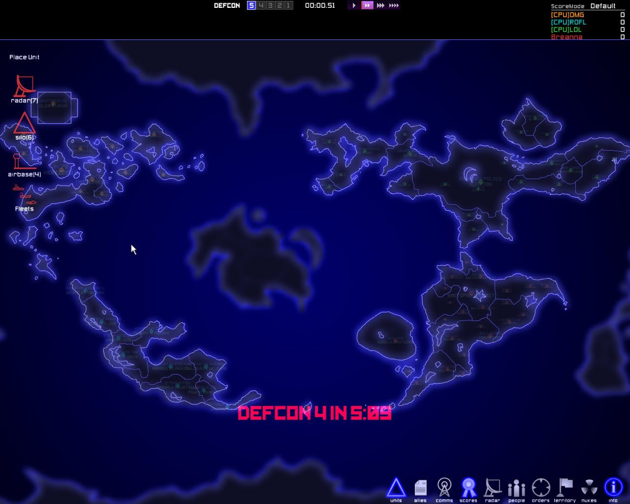
On the left and right side, there would appear to be two continents coming out of the edges of the map. in the game they would obviously be one continent as the world wraps. That however will be two countries playing on it. The left half and right half will be two players. Kinda like the europe/russia neighbor relationship in the original world.

The playable locations are:

1. West Humaleporis (the map edge continent mentioned above...
2. East Humaleporis ...also known as Rabbit Island)
3. Gloria Unida (the island chain in the northwest which includes a manmade rectangular land for HQ)
4. Xeta ek Avra (the curved sickle shaped continent in the south west)
5. Bretopia (the south-eastern continent including its satellite island)
6. Arias Marquisite (the expansive north-eastern continent and its satellite island)

And if you care about the names at all, the unplayable areas of the map are called:

- Pakuuta Culdrik (central island, including moon-shaped satellite island)
- Subjacent Polaris ("Antarctica" type continent at the south pole)
- Superjacent Polaris (Continent that makes up the north pole area)

I was considering adding 1 decent city for each player on the Pakuuta , and allowing the placement of a silo to defend it. but i thought maybe that would just annoy people so, nah.

News: Four of the nine continents, six playable territories have been vectored. Cities have been placed for each territory as well. Now, I need to finish vectoring, adjust the blur.bmp to match my changes to the coastlines and borders, and adjust and balance out city populations. Once these are achieved, the mod should be ready for release.
Last edited by Lazureus on Tue Oct 10, 2006 8:58 pm, edited 2 times in total.
Nib
level0
Posts: 8
Joined: Fri Nov 26, 2004 4:28 pm

Postby Nib » Sat Oct 07, 2006 1:58 am

Looks very nice !
User avatar
shinygerbil
level5
level5
Posts: 4667
Joined: Wed Dec 22, 2004 10:14 pm
Location: Out, finding my own food. Also, doing the shinyBonsai Manoeuvre(tm)
Contact:

Postby shinygerbil » Sat Oct 07, 2006 2:37 am

Now this sort of thing is what I'd like to see more of - just different maps, with different shaped countries and, therefore, different tactics and ways of playing. Nice work, I look forward to seeing this one develop :)
Here is my signature. Make of it what you will.
Image
User avatar
Kuth
level4
level4
Posts: 709
Joined: Sun Sep 10, 2006 5:55 am
Location: Keele Imperium
Contact:

Postby Kuth » Sat Oct 07, 2006 2:54 am

my question is how this would be handled in multiplayer...

Different icon sets are one thing- since the map is essentially the same- but would severs have to say what maps they were on? What if someone doesn't have the playmap that the server is using?
User avatar
Lazureus
level1
level1
Posts: 19
Joined: Fri Oct 06, 2006 3:15 pm
Contact:

Postby Lazureus » Sat Oct 07, 2006 6:23 am

hmm, even with that coordinate tool that came out, it's really hard to do the vector coastlines for my map because it's complicated and there's no way to zoom in on the tool (which is basically required if i'm gonna do this lol)

i'll have to wait until the tools get more features i suppose, unless someone wants to give me a hand >.>


I also cannot figure out the travel nodes. the file for it is 800x400 whereas the actual water and sailable bitmaps are 512x284
User avatar
shinygerbil
level5
level5
Posts: 4667
Joined: Wed Dec 22, 2004 10:14 pm
Location: Out, finding my own food. Also, doing the shinyBonsai Manoeuvre(tm)
Contact:

Postby shinygerbil » Sat Oct 07, 2006 12:11 pm

For the travel nodes, I just take the sailable.bmp, stick it in Paint, enlarge it and then zoom in and draw little circles on the map:

Image

Then fill the rest up with black. Just make sure they're all connected :)
User avatar
Lazureus
level1
level1
Posts: 19
Joined: Fri Oct 06, 2006 3:15 pm
Contact:

Postby Lazureus » Tue Oct 10, 2006 9:00 pm

http://i77.photobucket.com/albums/j67/L ... rTest2.jpg

A screenshot of how progress is on the mod. ^.^

I still got more vector coastlines and territories to finish up, some balancing on city populations, and adjust the blur.bmp further to match it up with my vectors (that'll be a doozy!)
denzil
level2
level2
Posts: 120
Joined: Wed Oct 04, 2006 5:59 pm
Location: Bournemouth, UK.
Contact:

Postby denzil » Tue Oct 10, 2006 9:09 pm

That must be insane to play, super fast! :D love it!
User avatar
KungFuAlex
level2
level2
Posts: 99
Joined: Sat Sep 30, 2006 3:46 am
Location: Norway

Postby KungFuAlex » Tue Oct 10, 2006 9:17 pm

Look promising! :)

Return to “Mod Projects”

Who is online

Users browsing this forum: No registered users and 6 guests